The Blue Ridge Parkway is a national parkway in the USA that connects the Shenandoah National Park to the Great Smoky Mountains. Its patrons enjoy 469 miles of scenic driving from Virginia to North Carolina. This is a great route to unwind in the heart of the southern Appalachians.
Exploring the full length of the parkway can take a week or more. This practical itinerary covers the first quarter classified as the Ridge region. You'll be seeing more articles on other regions as part of this series in the future.
Let's take a look at what the first 100 miles of Blue Ridge Parkway have to offer.
#TravelSmart Itinerary at a Glance
#TravelSmart Tips
Nearest Airports
Cheapest: IAD (120 miles), DCA (140 miles)
Closest: CHO (30 miles), SHD (30 miles)
Months of Operation
The parkway and its facilities start opening up during Spring i.e April-May. But to be sure about making the most of your trip, plan to be here after the Memorial Day (last weekend of May).
Updates and Alerts
Parkway Map
Use this interactive map to plan your road trip.
Getting Started
To put things into context for those who know about the famous Shenandoah National Park, the Blue Ridge Parkway begins and continues along the same road as the Skyline Drive. Unlike Shenandoah, no fees are charged to drive through the parkway.

Parkway Drive
Before beginning your parkway day from the northernmost entrance (see map below), visit the Rockfish Gap Information Center for any tips, updates, brochures or questions about the parkway.
It is not maintained by the NPS, but the center has knowledgeable staff and a 3D model of the surrounding area all the way from Harpers Ferry to Roanoke.
Accessible Viewpoints
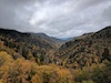
Once you set off, you will find numerous viewing points along the way. Start early to soak in all the natural vistas. If you’re an organized planner, use this exhaustive milepost by milepost guide.
Want a curated quality list of outlooks easily accessible by car? Here you go. MP means milepost.
- Ravens Roost (MP 10.7)
- Irish Creek Valley (MP 42.2)
- Terrapin Mountain (MP 72.6)
- Arnold Valley (MP 75.3)

Ravens Roost

Arnold Valley
Humpback Rocks
At milepost 6, you will come across the Humpback Rocks Visitor Center. Several trails begin from here. Check out this resource to plan an exciting hike to the Humpback Rocks.
Non-hikers can take the easy quarter-mile long Mountain Farm trail that passes through a historic mountain farm with cabins, cottages and other structures reminiscent of the 1890s.
James River

James River
James River marks the lowest elevation of the parkway i.e. only 649 feet at milepost 64. Stand at the bridge over the river to appreciate its sheer strength and walk on one of the James River trails.

Red Maple Tree

Trail of the Trees
The short yet beautiful Trail of the Trees is an absolute must-do. There is a visitor center here too that is only open from Friday to Sunday.
Peaks of Otter

Peaks of Otter Lake
Peaks of Otter at milepost 86 is the best area to camp in the parkway.
If you’re not a camper, you have the option to stay at the lodge too. If you are still not convinced to camp or lodge here, let me tell you the abundance of things you can do here.
Visit the historic Johnson Farm and Polly Woods Ordinary, go fishing at the Abbott lake during the day for some smallmouth bass and bluegill, take a stroll along the lake under the moonlight at night, try the delicious food of the restaurant at the lodge, and/or enjoy making s’mores under the stars at your campsite.

Campsite at Peaks of Otter
#TravelSmart Tips
Reserve the campsite online in advance.
You may spot a bear during your stay if you're lucky. Ask the ranger for tips to see one but don't get too close.
Sharp Top Mountain
After wrapping up your tents or checking out of the lodge the next day, hike the Sharp Top Mountain.
#TravelSmart Tip
Don’t wanna exert? No worries, a shuttle service charges only $10 and takes you up the mountain covering most of the climb. The return trip costs $12.

View of Peaks of Otter from Sharp Top Mountain
The 360-degree views from the summit of this imposing 4000 feet high mountain are breathtaking. The Peaks of Otter are directly below in sight with the Shenandoah Valley towards the west and the Piedmont region towards the east.
Before you leave, don’t forget to check out the visitor center for souvenirs across the road from the trailhead. For the curious, there are exhibits inside that highlight the various seasons of the Blue Ridge Parkway.
Bonus: Flap Top Mountain
For those looking for something challenging and strenuous on this trip, sweat out climbing the Flap Top Mountain at milepost 83.5.

Flat Top Mountain
It’s not the end
Slowly driving away from the Peaks of Otter and spotting a few overlooks for the next 14 miles, you will come to the end of the Ridge region at milepost 106, a short distance away from entering Roanoke.
They say Virginia is for Lovers and for lovers of mountains, valleys, trails and lakes, the Ridge region of the Blue Ridge Parkway will undoubtedly be a delightful experience.
The remaining regions namely Plateau, Pisgah, and Highlands are unique beauties in themselves. Keep driving down if you have time. The mountains are calling, and you must go unless you need to show up at work the next day.
#TravelSmart Budget
Parkway Fees
FREE
Campground Fees
$20 per night
Shuttle to Sharp Top
$12 return trip
Stay tuned for the itineraries covering the best of the other three regions of the parkway in the future. Until then, check out the other resources on this website if you’re mad over exploring!


Mad Over Exploring
My name is Sunkist and I am the creator of MOE. No, I haven’t sold my belongings and ditched my 9 to 5 job for an expedition around the world. In fact, I am just like you. I have a weekday job and only 15 days of vacation time in a year. I am economical but I also want quality experiences in a variety of destinations. Over the last few years, I have learned to #TravelSmart while I #ExploreAmerica and I simply want to pass my tips, itineraries, and stories to you. Are we clicking already? Well, then what are you waiting for?